

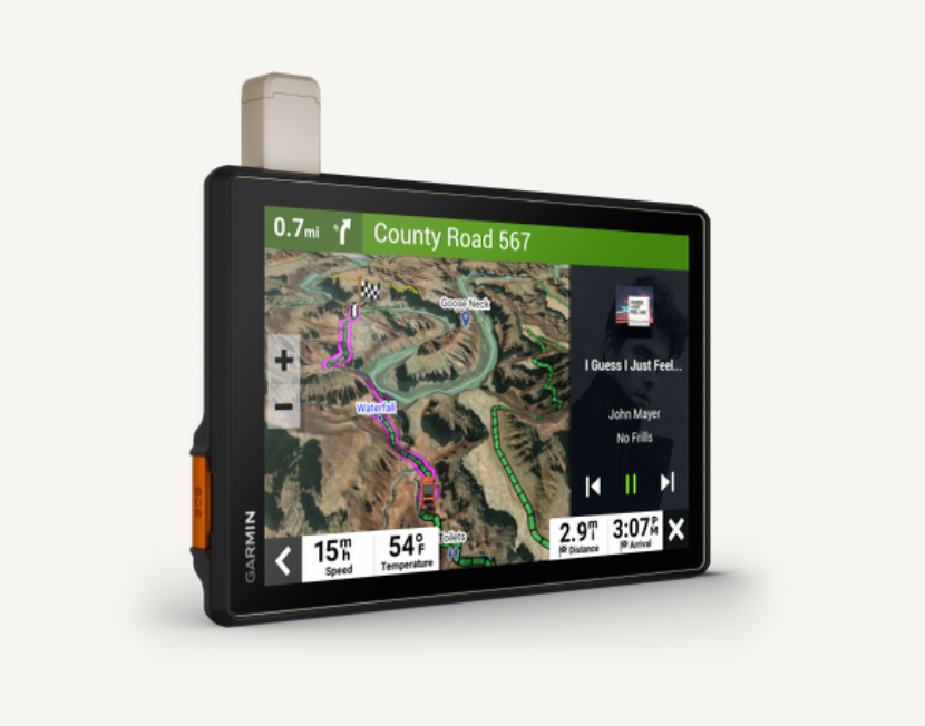
Roam the unknown with Tread® XL - Overland Edition. It's the extra big, extra rugged all-terrain navigator with a 10" ultrabright display made for every overlanding expedition. Enjoy turn-by-turn trail navigation' for traversing unpaved roads and trails plus custom street routing? for the size and weight of your vehicle. The navigator includes preloaded topography, subscription-free BirdsEye Satellite Imagery, Overlander™' points of interest and Ultimate Public Campgrounds, so you won't need a signal to route to the best-established, wild and dispersed campsites. With an active satellite subscription, built-in inReach® technology offers global satellite communication, two-way text messaging, location sharing
and interactive SOS. Pair your device to the Tread® app on your compatible smartphone to track up to 20 friends using the Group Ride Mobile' feature and plan routes with the same maps and route preferences that you have on the Tread device.
Rugged, weather-resistant (IP67)} all-terrain navigator with 10' ultrabright display; includes locking magnet-assisted mount for securing in your rig Turn-by-turn trail navigation? for unpaved roads and trails using adventure roads and trails map
content comprised of OSM and USFS Motor Vehicle Use Maps; City Navigator® road maps for custom street routing for the size and weight of your rig Preloaded topographic maps with 3D terrain of North and South America, U.S. public and private
landowner information and subscription-free BirdsEye Satellite Imagery via direct-to-device download Built-in inReach® technology offers global satellite communication, two-way text messaging, location sharing, interactive SOS and weather updates (requires an active subscription)*
Preloaded with Overlander™* points of interest and Ultimate Public Campgrounds, so you don't need a cell signal to route to the best-established, wild and dispersed campsites. Pair with the Tread® app on your compatible smartphone to track friends using the Group Ride Mobiles feature, sync your trip data across all your devices and plan routes with the same maps, vehicle profiles and route preferences that you have on the Tread® device Built-in altimeter, barometer, compass, and pitch and roll gauges help you navigate challenging terrain. Works with other Garmin off-road products, including the Group Ride Radio for group trackingó and communication plus the Garmin PowerSwitch™ digital switch box (each sold separately)
NOTE: Limitations may exist in map data for some road and trail route suggestions. Always defer to all posted road signs and conditions during vehicle operation. The Garmin OpenStreetMap products are intended to be used only as a supplementary travel aid and must not be used for any purpose requiring precise measurement of direction, distance, location or topography. Not available in all areas. Entering your vehicle's profile characteristics does not guarantee your vehicle's characteristics will be
accounted for in all route suggestions. Always defer to all posted road signs and road conditions.
*Active satellite subscription required for the inReach features. Some jurisdictions regulate or prohibit the use of satellite communications devices. It is your responsibility to know and follow all applicable laws in the jurisdictions where the device is
intended to be used.
Tracking via Group Ride Mobile requires the Tread app running on your and each friend's compatible smartphone with BLUETOOTH® technology and an active cellular connection
Copyright ©2021 by Overlander, LLC.
Copyright © 2021 Ultimate Campgrounds - All rights reserved.
The Bluetooth word mark
and logos are registered trademarks owned by Bluetooth SIG, Inc. and any use of such marks by Garmin is under license.